
Sept 25,2025
Typhoon Ragasa Weakens into Tropical Depression Before Entering Quang Ninh
(Dan Tri) - The National Center for Hydro-Meteorological Forecasting has just announced that Typhoon Ragasa has weakened into a tropical depression.
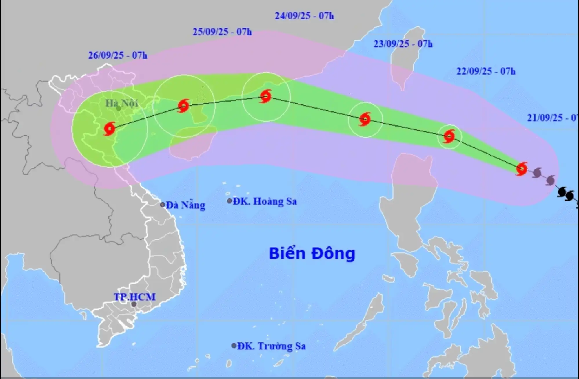
According to the National Center for Hydro-Meteorological Forecasting at 10:00 AM on September 25, Typhoon Ragasa has weakened into a tropical depression, located approximately 40 km east of Mong Cai (Quang Ninh Province), with maximum sustained winds of level 7, gusting to level 9.
The meteorological agency also reported that at 7:00 AM on the same day, the typhoon had downgraded to level 8, gusting to level 10, and was about 60 km east of Mong Cai (Quang Ninh Province). In the coming hours, the storm is moving westward at a speed of about 20 km/h.
The meteorological agency assesses that the typhoon is likely to weaken further into a tropical depression before making landfall in the Quang Ninh area this afternoon.
Due to the influence of the typhoon, the northern Gulf of Tonkin area (Bach Long Vi, Van Don, Co To, Cat Hai, Hon Dau) will experience strong winds of level 6-7, with winds near the storm's center reaching level 8, gusting to level 10, and waves of 2-3 meters, resulting in rough seas.
On land, coastal areas from Quang Ninh to Hai Phong will have strong winds of level 6, with some places reaching level 7, gusting to level 8-9. Inland areas in the Northeast region will experience gusty winds of level 6-7.
Forecasts indicate that from the morning of September 25 to the night of September 26, the Northern region, Thanh Hoa, and Nghe An will experience heavy to very heavy rain, with accumulated rainfall commonly ranging from 100-200 mm, and some localized areas exceeding 300 mm. There is a risk of urban flooding.
The meteorological agency warns that from September 25 to 27, a wave of flooding is likely to occur on rivers in the Northern region, Thanh Hoa, and Nghe An. The Thao River, Lo River, upper Thai Binh River, Hoang Long River, Buoi River, and upper Ma River will reach peak flood levels at alert 1-2, with some rivers exceeding alert 2.
There is a risk of flooding in low-lying areas, flash floods on small rivers and streams, and landslides on steep slopes.
Due to the broad circulation of the typhoon, caution is advised for thunderstorms, tornadoes, and strong gusty winds before and during the typhoon's landfall.
Sept 24,2025 (Dân Trí) - Forecast: Due to the influence of Typhoon Ragasa (Typhoon No. 9), the northern region will experience heavy to very heavy rain, with some areas exceeding 400mm. Localities need to prepare for intense rainfall that could cause urban flooding.
According to the National Center for Hydro-Meteorological Forecasting, from the night of September 24 to September 26, the Northern region, Thanh Hóa, and Nghệ An will see heavy to very heavy rain, with widespread amounts of 100-250mm, and locally over 400mm in some places.
The heavy rain is expected to concentrate in the provinces of Thái Nguyên, southern Tuyên Quang, Lào Cai, Phú Thọ, the northern delta region, and Thanh Hóa.
On September 25, rain will focus on Cao Bằng, Thái Nguyên, Lạng Sơn, Quảng Ninh, Hải Phòng, Bắc Ninh, and Hưng Yên.
On September 26-27, rain will occur in Phú Thọ, the northern delta region, and Thanh Hóa.
The above localities need to prepare for intense rainfall that could cause urban flooding.
The meteorological agency warns that heavy rain concentrated in short periods poses a particular risk of flash floods and landslides, mainly in the mountainous and midland areas of the Northern region, Thanh Hóa, and Nghệ An from September 25 to 27.
Regarding the development of Typhoon Ragasa, the National Center for Hydro-Meteorological Forecasting reports that at 7 PM on September 23, the typhoon's center was over the sea to the northeast of the northern East Sea region.
The strongest winds near the typhoon's center were at level 15-16 (167-201 km/h), with gusts exceeding level 17. In the next 24 hours, the typhoon will move westward-northwestward at about 20 km/h.
By the evening of September 24, Typhoon No. 9 will be over land near the coast of Guangdong Province (China), approximately 350 km east of Móng Cái (Quảng Ninh). The strongest winds near the center will be at level 13, with gusts up to level 16. The typhoon will mainly move westward-northwestward, at 20-25 km per hour, and gradually weaken.
At 7 AM on September 25, Typhoon No. 9 will be over the sea off Quảng Ninh - Hải Phòng with intensity at level 9, gusts up to level 11, moving mainly westward at 20-25 km per hour and continuing to weaken.
The influence of Typhoon Ragasa will bring heavy to very heavy rain to the northern region - 1
Due to the influence of Typhoon Ragasa, winds in the northern sea area of the northern East Sea will be strong at levels 10-13, levels 14-16 near the center, with gusts exceeding level 17. Waves will be over 10m high, and the sea will be very rough.
From September 24, winds in the eastern sea of the northern Gulf of Tonkin (including the special zone of Bạch Long Vỹ) will gradually strengthen to levels 6-7, with gusts up to level 9.
From the evening and night of September 24, the northern Gulf of Tonkin area (including the special zones of Bạch Long Vỹ, Vân Đồn, Cô Tô, Cát Hải, and Hòn Dấu Island) will see winds gradually strengthen to level 8, with waves 2-4m high; areas near the typhoon's path will reach levels 9-10, gusts up to level 12, with waves 3-5m high; the sea will be very rough.
Weather forecast for September 24 across the country:
Hà Nội: Partly cloudy, with showers and thunderstorms in some places at night, sunny during the day. Lowest temperature: 25-27°C. Highest temperature: 33-35°C.
Northwest region: Partly cloudy, scattered showers and thunderstorms at night, with heavy rain in some places locally; sunny during the day. During thunderstorms, there is a possibility of tornadoes, lightning, and strong gusts. Lowest temperature: 23-26°C, some places below 22°C. Highest temperature: 32-35°C.
Northeast region: Partly cloudy, showers and thunderstorms in some places at night. During thunderstorms, there is a possibility of tornadoes, lightning, and strong gusts. Lowest temperature: 24-27°C, some mountainous areas below 24°C. Highest temperature: 32-35°C.
From Thanh Hóa to Huế: Partly cloudy, scattered showers and thunderstorms at night, with heavy rain in some places locally; showers and thunderstorms in some places during the day. During thunderstorms, there is a possibility of tornadoes, lightning, hail, and strong gusts. Lowest temperature: 24-27°C. Highest temperature: 31-34°C.
South Central Coast: Partly cloudy, showers and thunderstorms in some places; the northern part will have scattered showers and thunderstorms at night, with heavy rain in some places locally. Lowest temperature: 24-27°C. Highest temperature: 31-34°C, some places over 34°C.
Central Highlands: Cloudy, with rain, moderate rain, and scattered thunderstorms, heavy to very heavy rain in some places locally. During thunderstorms, there is a possibility of tornadoes, lightning, hail, and strong gusts. Lowest temperature: 19-22°C. Highest temperature: 25-28°C.
Southern region: Partly cloudy, showers and thunderstorms in some places in the West, scattered in the afternoon and evening, heavy rain in some places locally; rain and moderate rain with scattered thunderstorms in the East, heavy to very heavy rain in some places locally (rain concentrated in the afternoon and evening). During thunderstorms, there is a possibility of tornadoes, lightning, hail, and strong gusts. Lowest temperature: 23-26°C. Highest temperature: 30-33°C.
Ho Chi Minh City: Partly cloudy, with rain, moderate rain, and scattered thunderstorms, heavy rain in some places locally (rain concentrated in the afternoon and evening). During thunderstorms, there is a possibility of tornadoes, lightning, hail, and strong gusts. Lowest temperature: 24-26°C. Highest temperature: 31-33°C.
=====
Sept 21,2025 (Dantri) – In just two days, Typhoon Ragasa has rapidly intensified by 6 categories to Category 14, with gusts reaching Category 17. Forecasts indicate that on September 22, the typhoon will strengthen further to Category 16, with gusts exceeding Category 17—reaching super typhoon status—before entering the South China Sea.
According to the National Center for Hydro-Meteorological Forecasting, as of the morning of September 21, Typhoon Ragasa had reached Category 14 (wind speeds of 150-166 km/h), with gusts at Category 17, located approximately 500 km east of Luzon Island, Philippines. The typhoon is moving west-northwest at about 15 km/h.
This means Ragasa has intensified by 6 categories in just two days.
Forecasts for the morning of September 22 predict the typhoon will reach Category 16, with gusts above Category 17, classifying it as a super typhoon. By the morning of September 23, Ragasa is expected to enter the South China Sea as the ninth storm of the season, maintaining Category 16-17 intensity with gusts exceeding Category 17.
The meteorological agency further forecasts that on September 24, the typhoon will weaken slightly to Category 15, with gusts at Category 17, while operating over the waters of Guangdong Province, China. Over the next 72 to 120 hours, Ragasa is expected to move west-southwest at approximately 20 km/h and gradually weaken.
Due to the typhoon’s influence, from September 22, the eastern area of the northern South China Sea will experience increasing winds from Category 8-9, escalating to Category 10-14, with areas near the typhoon’s center experiencing Category 15-17 winds and gusts above Category 17. Sea waves are expected to exceed 10 meters, causing extremely rough seas.
Vessels operating in the danger zone face a high risk of severe thunderstorms, tornadoes, strong winds, and large waves.
Mr. Nguyen Van Huong, Head of Weather Forecasting at the National Center for Hydro-Meteorological Forecasting, stated that Ragasa is likely to be the first super typhoon in the Northwest Pacific region this storm season.
Mr. Huong noted that Ragasa’s path is relatively complex, with international forecasts varying. One scenario suggests the typhoon will move toward Taiwan, which would minimize its impact on Vietnam; however, this scenario has only about a 20% probability.
The most likely scenario is that Ragasa will enter the South China Sea on September 23. Once in the South China Sea, two possibilities exist: one, the typhoon moves toward Guangdong Province, China, passing through Leizhou Peninsula and then affecting mainland Vietnam, but with significantly weakened intensity.
The second possibility is that the typhoon moves predominantly westward within the South China Sea, which would bring stronger winds and heavier rainfall to Vietnam.
Additionally, Mr. Huong mentioned that a cold air mass in the north could influence the typhoon’s direction. Forecasts indicate that from September 25 to 27, Northern Vietnam and the region from Thanh Hoa to Hue may experience heavy rain and strong winds.
The expert emphasized that since Ragasa will only enter the South China Sea around September 23, the forecast of its impact remains uncertain at this time. Residents are advised to closely monitor upcoming typhoon updates.


